
Who doesn’t love a good ghost town? With their colorful history and unique remnants of the past, visiting a California ghost town is a great way to spend the day.
Many ghost towns are shells of what they were during their rough and rowdy heydays, but each leaves a clue about the history of the state and its impressive mining history. After all, it was mining that led the masses flocking to what would become the Golden State.
Most of these California ghost towns are in remote locations, but each has a fascinating story to tell. Use this guide to find a ghost town on your next road trip route, and spend a couple hours exploring.
Best Ghost Towns in California to Explore
Calico Ghost Town– A Family-Friendly Old West Experience
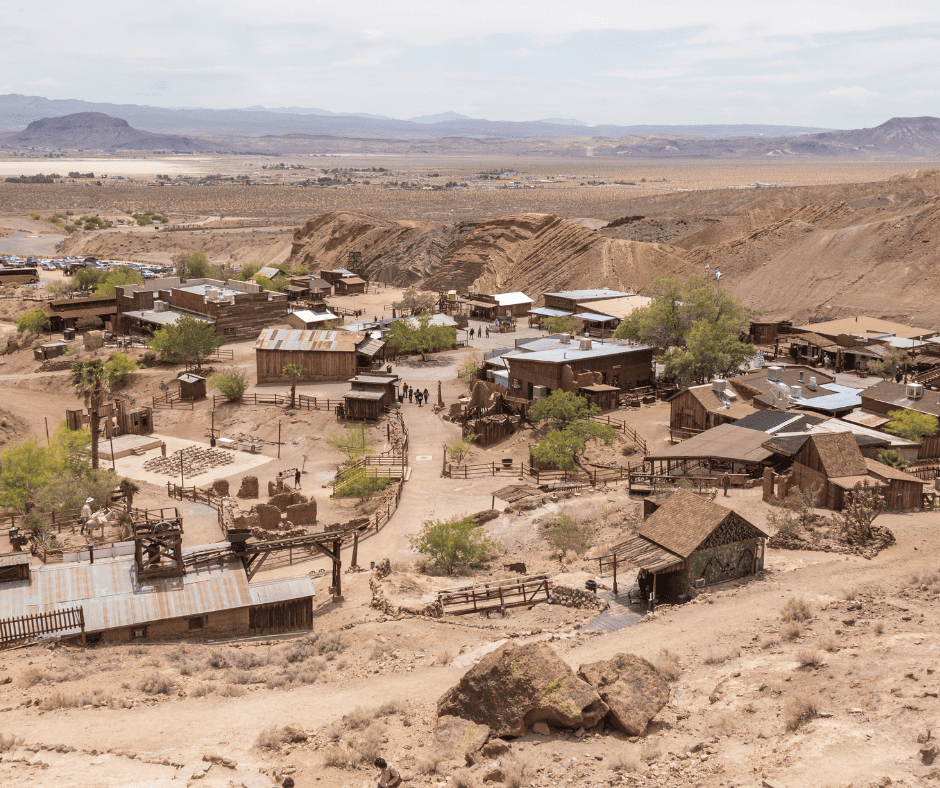
What makes it unique: Founded during the largest silver strike in California, Calico was once home to over 500 mines. Today, it’s a recreation of an Old West mining town, with restored buildings, costumed interpreters, and interactive attractions that bring the 1880s to life.
If you have driven Interstate 15 from Southern California to Las Vegas, you have passed right by Calico Ghost Town. This California ghost town is located just outside of Barstow and is the most popular ghost town in the state.
Calico was founded in 1881 during the silver mining boom in California. The town quickly grew as miners flocked to the area in search of silver. The boom in silver mining, however, was short-lived. By the mid-1890s, the price of silver dropped, leading to the closure of many mines. As a result, Calico’s population dwindled, and the town was eventually abandoned.
In the 1950s, Walter Knott, of Knott’s Berry Farm fame, purchased Calico and began to restore the town which eventually became a county park and popular tourist attraction. The town is designed to reflect its late 19th-century appearance.
The Calico Odessa Railroad is a narrow-gauge railroad which gives visitors train rides around the town. I remember taking a field trip out Calico when I was in kindergarten and absolutely loving that train ride!
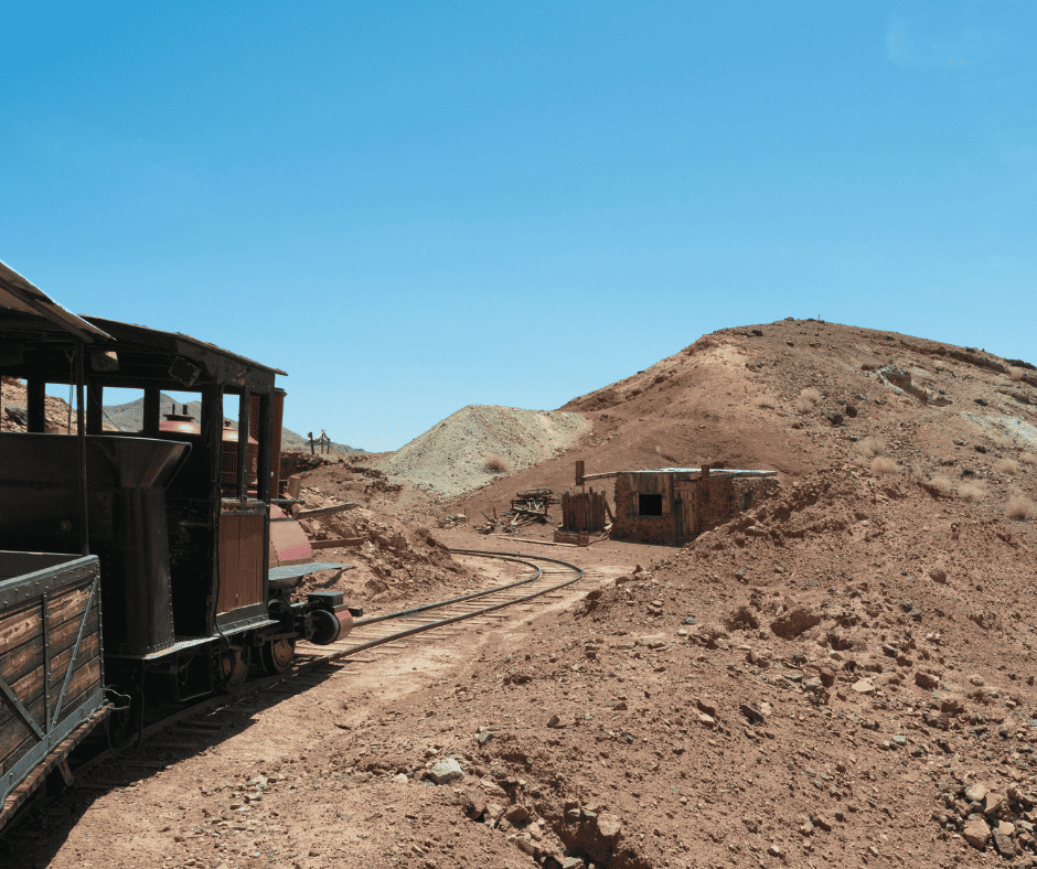
There are also several historic buildings to explore including the former schoolhouse, general store, and the Maggie Mine. Visitors can walk 1000 feet into Maggie Mine as they take a self-guided tour and look at minerals in the rock and learn about the mine and the miners that worked there in the late 19th century.
If you have ever been to Knott’s Berry Farm, then you will be familiar with the Mystery Shack where water runs uphill and crooked rooms play mind tricks. Mr. Knott added a Mystery Shack to Calico Ghost Town and it is always fun to explore. There is also gold panning onsite where kids will be excited to take home some iron pyrite aka: Fool’s Gold.
For $12, adults can purchase a package that allows them to tour the mine, visit the Mystery Shack, and pan for gold. Kids 5 – 11 are just $6. The railroad is a separate cost- $5.50 for adults and $3 for kids.
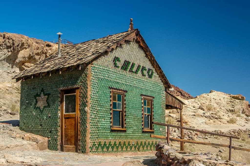
In addition to the special attractions there is a restored schoolhouse, town hall, bottle house, general store, woodworking shop, mineral shop, old-time photo store, and a handful of other shops. The Lucy Lane Museum has artifacts, photographs and documents from Calico’s origin. There are a couple restaurants serving food as well.
During the last two weekends in October Calico Ghost Town hosts Town of Terror with scary attractions from 5-9pm on Fridays and 5-10pm on Saturdays. They also host three different ghost tours- Main Street, Maggie Mine, and Schoolhouse. Tours happen on Saturday nights at 6pm and 7:30pm.
Visiting Tips: Calico Ghost Town is open from 9am to 5pm daily, except on Christmas Day. Temperatures are HOT in the summer so visit early during this time of year.
Nearby Lodging:
KOA Calico – Family-friendly camping and RV park right next to the ghost town. Offers cabins, a playground, and a pool.
Best Western Desert Villa Inn (Barstow) – Clean, chain hotel about 15 minutes away with breakfast and pool.
Here are 75 California landmarks you need to visit.
Bodie State Historical Park Ghost Town– California’s Best-Preserved Ghost Town
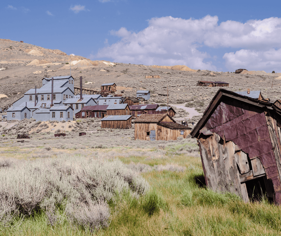
What makes it unique: One of the best-preserved Gold Rush ghost towns in the U.S., home to around110 buildings frozen in time.
Bodie State Historical Park is a California ghost town in the Eastern Sierra, about 75 minutes north of the popular Mammoth Lakes resort area and 30 minutes east of the town of Bridgeport.
Bodie made our list of the best state parks in California. See what other parks made the list!
It began as a small mining camp after gold was discovered in the area in 1859. The town was named after Waterman S. Body (William Bodey), who discovered gold there. In the 1870s and 1880s, the town “boomed” as gold mining operations expanded. At its peak, Bodie had a population of around 10,000 people and was known for its rough and lawless reputation.
The Standard Mine, one of the most productive in Bodie, yielded millions of dollars in gold during its operation but like many other mining towns, Bodie’s prosperity was short-lived. By the early 20th century, the gold began to run out, and the town’s population started to decline. By the 1940s, Bodie was almost entirely deserted.
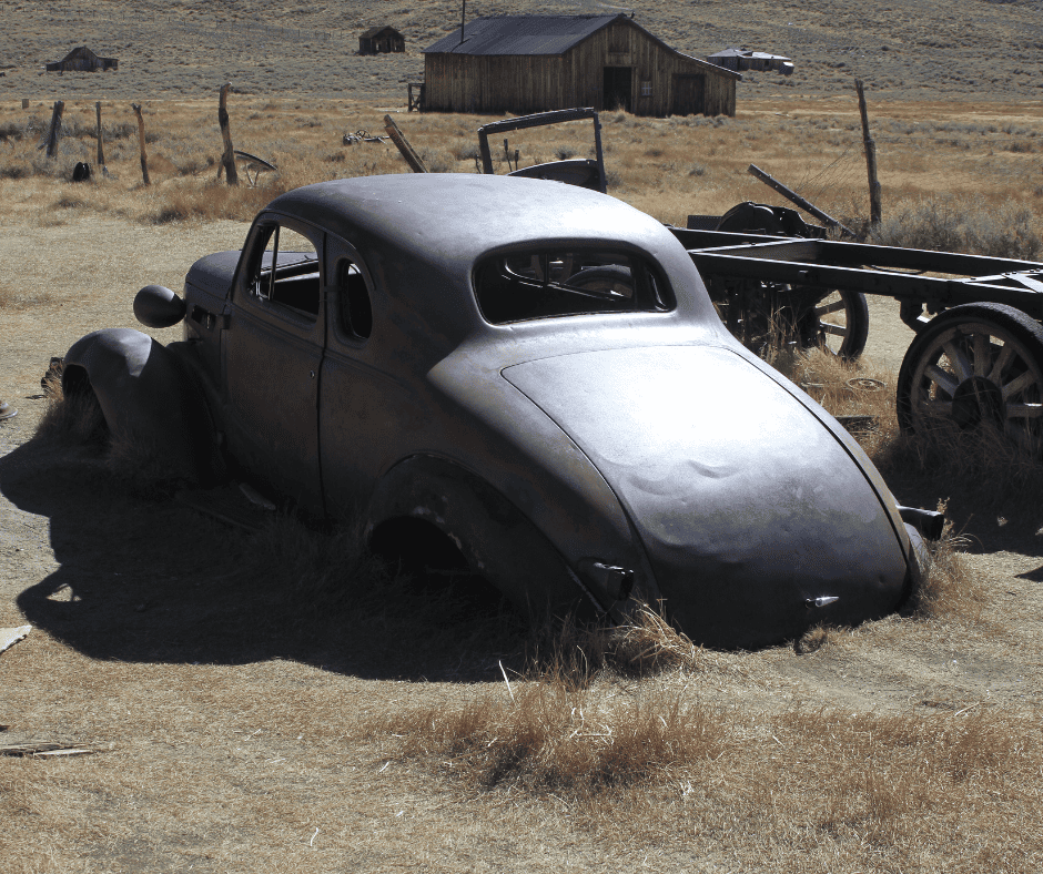
Thankfully, in 1962, the State of California took over the Bodie State Historic Park, and efforts were made to preserve the town in a state of arrested decay. This means that the buildings are maintained but not restored to a pristine condition, giving visitors a sense of how the town looked when it was abandoned. Visitors will discover cups left on tables, a wheelbarrow dumped over in a yard, and even a tricycle parked on a porch.
Only about five percent remains of the original town of 2,000 buildings, but more than 100 buildings still stand, including homes, stores, a church, and a school. Visitors to Bodie can explore the streets and enter some of the buildings. Guided tours of the Stamp Mill are available during peak season and highly recommended.
Technically, Bodie is open all year but it is accessible only by skis, snowshoes or snowmobiles during winter months because of its high elevation (8,375′).
Visiting Tips: Bodie is open to cars and fully staffed with park rangers Memorial Day through Labor Day. The road will close once it starts snowing for the season. It is a 13 mile journey off Highway 395 and the last three miles are unpaved, but most cars are fine on the road. Admission is $8 per adult and $5 per child 4 – 17.
Nearby Lodging:
Silver Maple Inn (Bridgeport)- About 12 miles from Bodie, this property has homestyle charm and modern amenities. Lawn seating, a playground, bike rentals, and barbecue grills add to the vibe.
Bridgeport Reservoir Campground (10 miles away)- Family-friendly campground with tent and full hook-up RV sites. Boat rentals available onsite.
Darwin– Isolation, Art, and Eerie Silence
What makes it special: Unlike many ghost towns, Darwin still has a handful of quirky, off-the-grid residents, giving it an eerie “half-alive” feel.
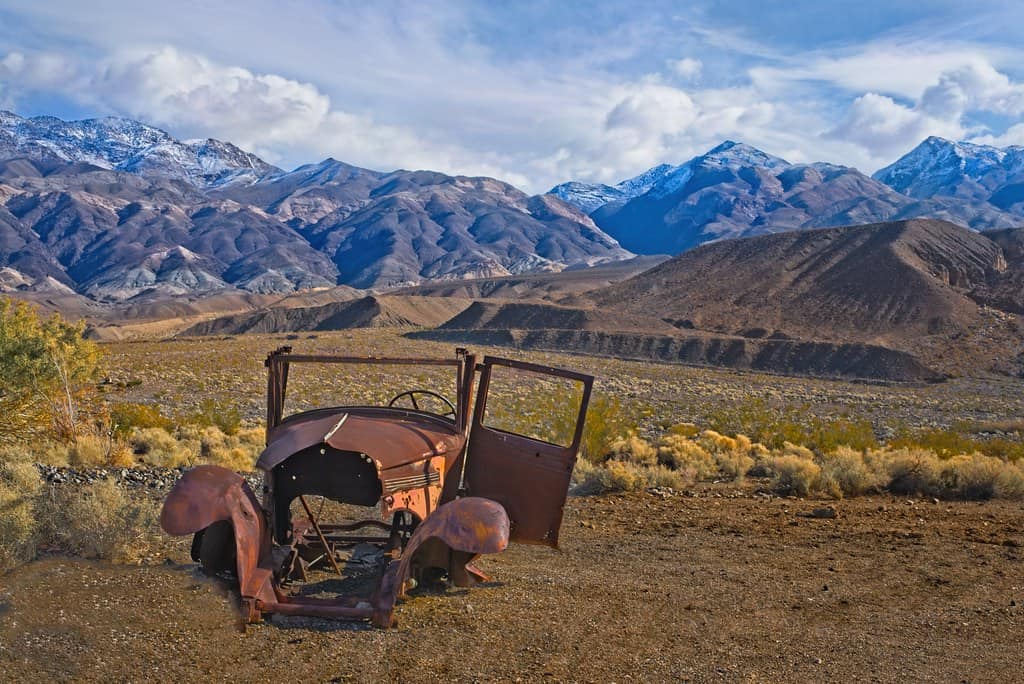
Way out in the middle of nowhere, but not far from the northern reaches of Death Valley, is the town of Darwin, a quiet, semi-ghost town. It is located in Inyo County, about two hours north of Ridgecrest and 40 minutes south of Lone Pine. About 40 people do still live in Darwin so it isn’t technically deserted, but it might as well be.
Like most California ghost towns, Darwin’s history is tied to mining, particularly lead and zinc. The town experienced its peak during the late 1870s when it had 3500 residents and was the second largest town in the county at the time. It had about 20 operating mines, hundreds of homes, a post office, saloons, restaurants, a hotel, and even a newspaper!
It was also a particularly rowdy and lawless town, thanks in big part to its isolation and gun fights and stage robberies were common.
Mining declined due to several factors including an outbreak of smallpox, a countrywide economic recession, and the movement of many miners up north to Bodie. An arson fire in 1879 wiped out a big portion of the heart of the town and by 1880, just 85 people remained. Despite the small population, mining did continue on some level in the area through the 1970s.
Visitors can explore the remnants of old buildings, mining structures, vehicles, and equipment. The town has an authentic, weathered feel, providing a sense of what life was like during its mining heyday. The remains of the old Defiance smelter still exist as well. On the hillside of Mt. Ophir there are remnants of the company camp, including decaying rows of company houses.
Visiting tips: Located west of Death Valley National Park, Darwin can be reached via CA-190 and a short detour on a well-maintained but desolate road. No services exist in town, so bring water and supplies. Be respectful of private property and residences when you visit this semi-ghost town.
Nearby Lodging:
Panamint Springs Resort (30 min away) – Rustic motel and cabins in Death Valley National Park with a restaurant and gas station.
Lone Pine Campground (1 hr away) – Forest service campground at the base of the Eastern Sierra, ideal for RV campers.
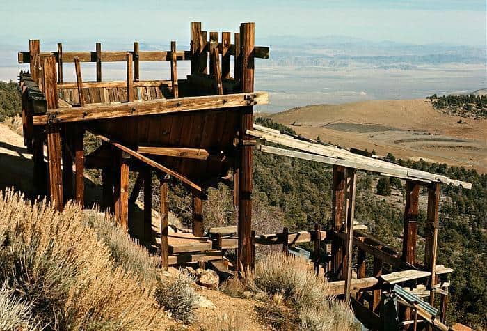
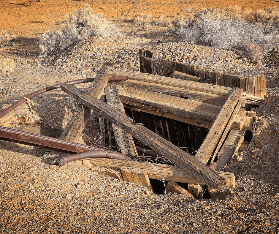
Panamint City– The Ghost Town Adventurers Hike To
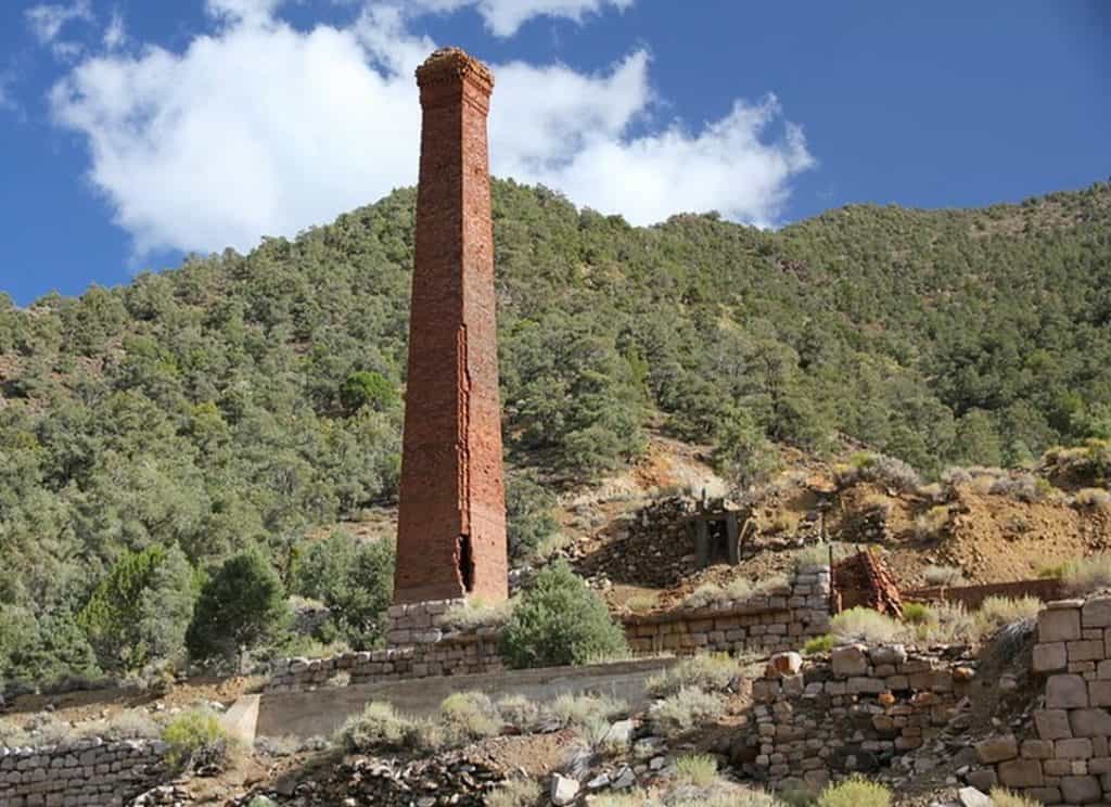
What makes it unique: Known as the “most inaccessible ghost town in California,” Panamint City is a treasure for experienced hikers who love an adventure. It is estimated to have less than 1,000 annual visitors.
Death Valley has its very own ghost town in the Panamint Mountains of the northern portion of the park. Panamint City was founded by a trio of prospectors in the early 1870s who found a deposit of silver ore in Surprise Canyon. Unfortunately, they were followed into the area by bandits who forced them into a partnership on the profits made by the mine.
It didn’t take long for word to get out about the newly formed Panamint Mining Company and soon hundreds of miners flocked to the area. Soon there were 2,000 people in town, along with saloons, a bank, restaurants, a brewery, a newspaper, and lots of ramshackle houses.
It was an especially wild and lawless area, complete with its very own red light district and dozens of shootings. Alas, the town did not last long. In 1876 two of the main mines were exhausted of ore and a large flood wiped out much of the town.
Not much of this ghost town remains except for some foundations, and the crumbling smokestack of Surprise Valley Mill and Water Company.
Access is challenging, involving a steep and strenuous seven-mile hike up Surprise Canyon which should only be attempted by seasoned hikers in the cool season. Here are some of the animals in Death Valley which you may encounter on your hike.
Lodging suggestions are the same as those for Darwin.
Ballarat– The Gateway to Death Valley History
Ballarat is a ghost town in Death Valley National Park at the base of the Panamint Range. It was founded in 1897 to serve as a supply point for the mines in the Panamint Range, including the nearby Ratliff Mine. It was named after the Australian gold mining camp of Ballarat.
Ballarat experienced a boom during the early 1900s as mining activity increased in the Panamint Range. Life was especially tough in the summer, when temperatures would soar over 120 degrees, but 500 hardy folks endured the heat at the town’s peak.
And of course these 500 residents needed seven saloons, because this was the Wild West after all! However, like many other mining towns in the region, its prosperity was short-lived.
What makes this California ghost town especially interesting and unique is its connection with the Manson Family. In the late 1960s, Charles Manson and his followers lived in the area at Barker Ranch south of Ballarat, and members of the Manson Family left graffiti in an old truck they abandoned in town.
Seldom Seen Slim is Ballarat’s most famous resident, who lived in town from around 1918 until 1968 when he died. He was the last to be buried at the town’s cemetery, aka Boot Hill. He claimed to be “half coyote and half wild burro” and said he hadn’t taken a bath for 20 years!
There are still a couple people that live in Ballarat and operate a small store. There are remains of old adobe structures to visit as well as several miner cabins. Unlike Darwin, Ballarat is accessible by vehicle, and is located off State Route 178, approximately four miles south of the park boundary.
North Bloomfield– Hidden in the Sierra Foothills
What makes it unique: The town is closely associated with the Malakoff Diggins, one of the largest hydraulic mining operations in California history.
About 15 miles northeast of Nevada City in the heart of Sierra Nevada Gold Country is North Bloomfield, a preserved gold rush town that is now a state park.
Nevada City is one of our favorite weekend getaways in Northern California.
Originally named Humbug because of some failed gold mining attempts, North Bloomfield was established in 1851 after a few prospectors found gold in a nearby creek. Once gold was discovered in the area, a rush of prospectors and settlers seeking their fortunes flocked to the area.
By the late 1860s, North Bloomfield Gravel Mining Company employed 1100 people, including 800 Chinese workers. The population of the town reached a height of 2000 residents. The company used hydraulic mining which uses highly pressured water to basically blast away mountainsides in the pursuit of gold.
As you can imagine, hydraulic mining was absolutely terrible for the environment and a law was passed in 1884 to make the current system illegal. Once that happened, operations at the mine should have ceased, but they didn’t. Instead they installed a new system to pull debris from the tailings and retain it in holding ponds.
Then the mine basically ignored that law as well as the law passed by Congress in 1893 requiring all hydraulic mines to be licensed. In the late 1800s the law and all the resulting fines caught up with the North Bloomfield Gravel Mining Company and operations were ceased. They left behind a massive pit.
The population continued to dwindle until less than 20 people remained. At that point, the locals urged the state to preserve and protect the historic area. In 1965 Malakoff Diggins State Historic Park was established.
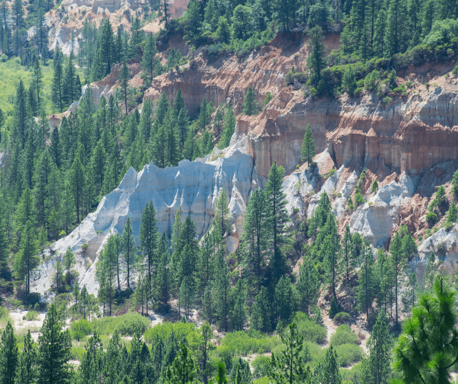
Today, the state park encompasses the remnants of the hydraulic mining infrastructure, including towering cliffs and the townsite. One of the central features of the historic park is the enormous tailings piles resulting from the hydraulic mining operations.
Visitors can also view the restored and operational Malakoff Diggins Dredge, which is a large floating gold dredge that was used to extract gold from the sediment.
Within the park, visitors can explore various historical landmarks, such as the North Bloomfield Schoolhouse, which is a well-preserved one-room schoolhouse dating back to the 1870s, and the cemetery where some early residents are buried. There is also a drug store, church, and several houses.
Visiting tip: This park is best accessed from late spring through fall because some roads may be closed or muddy in winter.
Nearby Lodging:
Three miner’s cabins in North Bloomfield may be reserved for camping. The area is quite scenic and has several miles of trails so spending a couple days here makes for a lovely getaway.
Northern Queen Inn (Nevada City) – Cozy rooms with kitchenettes, free parking, and complimentary breakfast. It’s just a 10‑minute drive to the Park and surrounded by pine‑forest.
Doble– The Forgotten Ghost Town of Big Bear
Doble is a former mining community located in the San Bernardino Mountains near Big Bear Lake. It was originally named Bairdstown but the name changed to Doble, named for horse trainer and silent movie actor, Budd Doble.
Doble’s history dates back to the late 1800s when it was primarily a mining and logging town. The area was rich in timber, and the timber industry played a significant role in the town’s early development. In 1875 there was a butcher shop, a bakery, several saloons, three general stores, two livery stables, three restaurants, two hotels, a black smith shop, a cemetery, and much more. This town was legit!
It did experience a brief period of silver mining activity when several mines operated in the surrounding mountains. At that time, the Doble Mine Mill processed 100 tons of ore per day. However, the mining boom was short-lived and last only about 8 months.
Another attempt was made to rebuild the mill (the original burned down) in 1899 with a promising new “Cyanide Process” to mine the region’s poor quality ore but the mine shut down in 1903 and the town became a ghost town.
Ruins of the 1875 Stamp Mill and the cemetery are all that remain today. Still, if you are exploring the Big Bear Lake area, it is worth a stop. Baldwin Lake is within view of the ruins because most of the trees in the area were cut down to help run the steam engine for the stamp mill. Most of the trees in the area these days are second generation growth.
Visiting tips: Doble is best reached via 4WD from Baldwin Lake near Big Bear. Expect no services, signage, or maintained trails
Stay Nearby: Best Western Big Bear Chateau Boutique Hotel – Has suites with kitchenettes and indoor pool. Less than a mile from skiing in the winter and lake play in the summer.
Big Bear Lake is one of our favorite weekend getaways in Southern California.
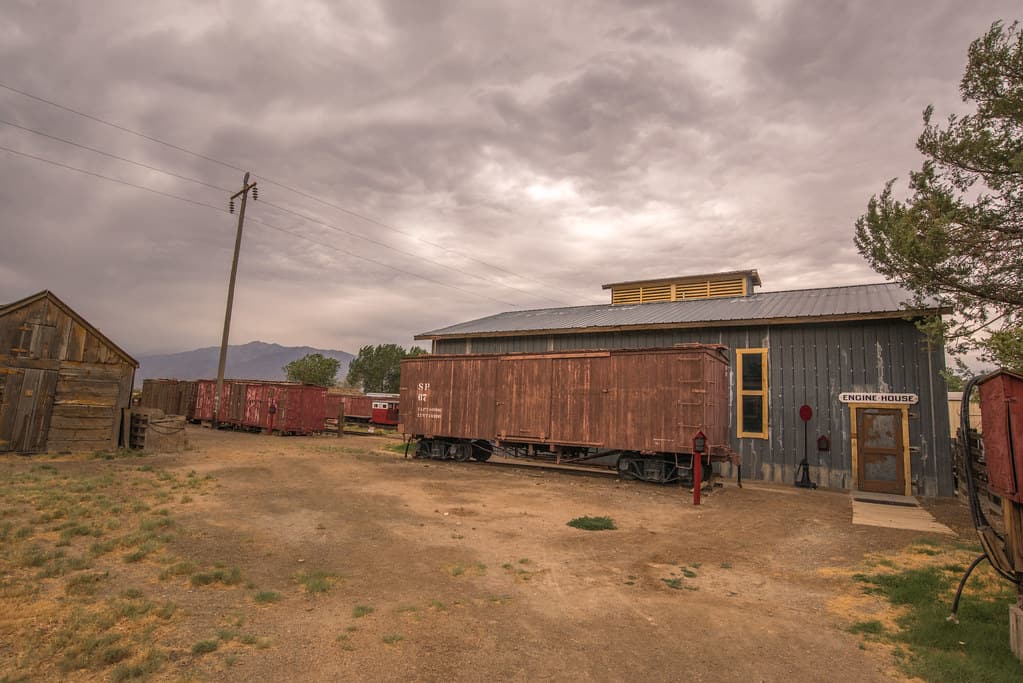
Laws– The Railroad Hub of the Owens Valley
Laws is a historic site and former railroad town located in the Owens Valley, a few miles north of the town of Bishop on Highway 395. It is not a traditional ghost town, but rather a preserved area that showcases the history of the Owens Valley and the Eastern Sierra.
Laws began as a station on the Carson and Colorado Railroad in the late 19th century. The railroad played a crucial role in the development of the Owens Valley by providing transportation for mining and agricultural products. It became a hub for maintenance, repairs, and other services related to the operation of the narrow-gauge railroad and an essential stop for trains traveling through the Owens Valley.
The Great Depression hit Laws hard and in 1938, Southern Pacific tore up the rail lines north of town. Still, the town persisted as the northern terminus until the railroad fully shut down the narrow gauge line between Keeler and Laws in 1960.
Today, Laws is home to the Laws Railroad Museum and Historic Site. The museum features a collection of historic buildings, vintage railroad equipment, and artifacts from the late 19th and early 20th centuries. Visitors can explore the original depot, a schoolhouse, a blacksmith shop, and various railway cars. Some of the buildings were moved to their current location inside the museum.
Paramount Pictures made the film, Nevada Smith, on the site in 1966 and the Laws Railroad Museum protects buildings from that set as well. It also houses a collection of steam and diesel locomotives, as well as a variety of rolling stock.
Laws is listed on the National Registry of Historic Places. It is open from 10am – 4pm except for Thanksgiving, Christmas, and New Years Day. Admission is a $10 donation.
Nearby Lodging:
Wayfinder Bishop: A cute hotel in the heart of Bishop with a nice pool area and location along the creek. Plus it is right next door to the famous Erick Schat’s Bakery!
Bishop Park Campground: A popular spot along the Middle Fork of Bishop Creek with tent and RV sites. HIking, fishing, and horseback riding all nearby.
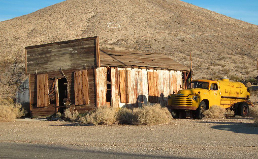
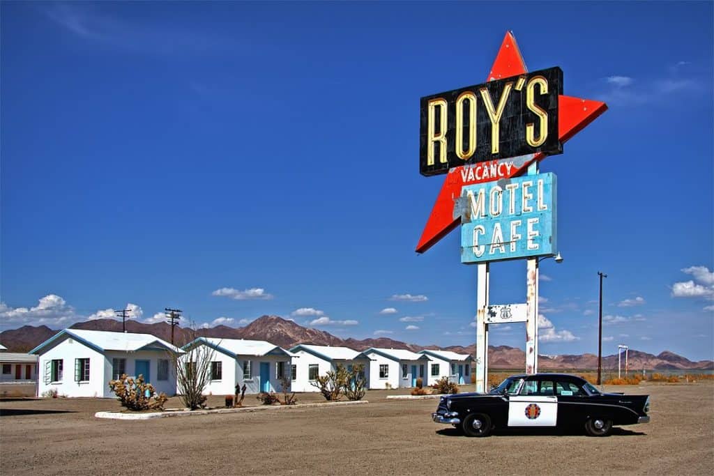
Amboy– Route 66’s Silent Sentinel in the Mojave
What makes it unique: Its a classive Mojave Desert ghost town with a Route 66 history as well.
Amboy was founded as a railroad and mining town in the Mojave Desert. However, its location halfway between Barstow and Needle on Route 66, the most popular route out west back before the advent of the Interstate Highway system, made the town a popular tourist stop for travelers heading to California.
When Interstate 40 opened in 1973, 100 miles of Route 66 in the Mojave Desert were basically deserted. And with it went all the towns that lined that stretch, including Amboy.
Amboy began as a mining camp in 1858 and was named in 1883 when the first railway tracks were being built in the area. It was never a big town. Only 200 people lived there during its heyday of the 1930s and 40s. At that time the town had 13 businesses, three gas stations, three motels, a couple cafes, a post office, a church and even a small school.
Amboy is best known for Roy’s Motel and Café, an iconic roadside stop along Route 66. Roy’s became a symbol of the classic American road trip, featuring the distinctive Googie architecture and neon signs that were popular in the mid-20th century.
With the construction of Interstate 40 which bypassed Route 66, traffic through Amboy declined significantly. The town’s businesses struggled, and by the late 20th century, Amboy had become a near-ghost town.
In 2005, Amboy was purchased by Albert Okura, the founder of the Juan Pollo restaurant chain, for just $425,000. Okura aims to restore and preserve the town’s historic features, including Roy’s Motel and Café.
Roy’s, with its classic mid-century design, includes a motel, café, and gas station. While the motel is no longer operational, the café is occasionally open, and the site attracts visitors interested in its nostalgic appeal.
Roy’s famed neon sign was relit in 2019 after many decades of disrepair. There are continued plans to renovate the motel, add a gift shop, update the gas station to be a 24-hour self serve establishment, and get a food permit so the restaurant can once again sell more than food. Installing a water system is another key aspect of the rehab to be tackled.
While in Amboy, make time to visit Amboy Crater, a volcanic cinder cone that rises prominently from the desert landscape. It is a popular hiking destination, offering panoramic views of the surrounding desert.
Nearby Lodging: You are better off stopping here on your way across the desert because there isn’t much nearby. You can stay in one of the lodging options near Lake Havasu or at a hotel in Barstow like the TownePlace Suites.
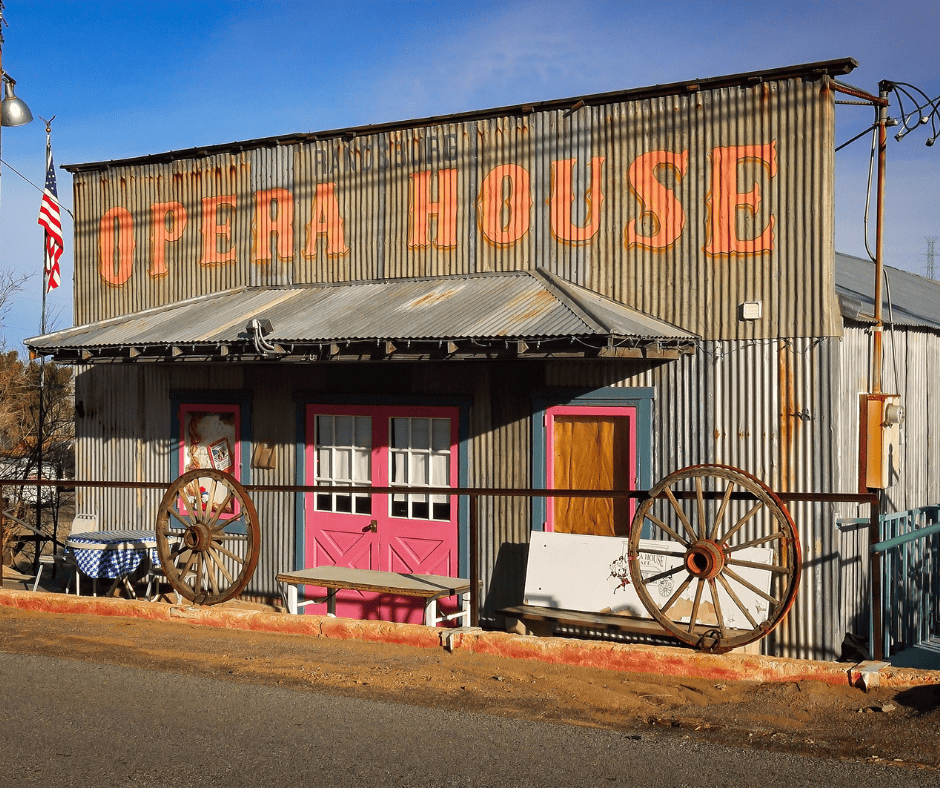
Randsburg– Alive with Art and Antiques
What makes it special: This ghost town is still inhabited by a few hearty folks.
Known as the “Living Ghost Town,” Randsburg has a mix of abandoned and occupied buildings, showcasing its mining and Old West history near the junction of Highway 395 and Highway 14 in the Mojave Desert of Kern County about 17 miles south of Ridgecrest. Less than 50 people live in the area today.
Randsburg’s history began with the discovery of gold in 1895 by three prospectors: John Singleton, Charles Burcham, and Henry Singleton. The discovery sparked a gold rush, leading to the rapid growth of the town.
Randsburg was unique in that it was situated at the junction of three major mining districts: Randsburg, Johannesburg, and Red Mountain. The combined output of these districts contributed significantly to the town’s prosperity.
As the town grew, it developed essential infrastructure such as schools, churches, saloons, and stores. The Yellow Aster Mine, one of the most successful gold mines in the region, brought considerable wealth to the area. The population grew to over 4000 people in the early 1900s.
Like many mining towns, Randsburg faced a decline in the early 20th century as the easily accessible gold was depleted. The town’s population dwindled, and many businesses closed, especially during World War II when mining for gold was considered non-essential. However, some mining operations continued into the mid-20th century.
In the latter part of the 20th century, there was renewed interest in preserving and restoring Randsburg’s historic buildings. Many structures from the town’s heyday still stand, providing visitors with a glimpse into its past. Randsburg has been designated a California Historical Landmark (#285) due to its significance in the state’s history as a major mining town during the Gold Rush era.
Today, Randsburg is a popular tourist attraction, drawing visitors with its well-preserved ghost town atmosphere. Visitors can explore the historic district, including the 1896 White House Saloon, opera house, a tiny jail cell, and other vintage and dilapidated structures and rusted-out abandoned vehicles.
Be sure to visit the Randsburg General Store which opened in the 1930s. It has a soda fountain from 1904 where you can still order soda, shakes, and ice cream sundaes.
Nearby Lodging:
Ridgecrest (17 miles north)- Ridgecrest is home to several chain hotels such as the Holiday Inn Express and Springhill Suites which offer pools, clean rooms, and free breakfast.
Ricardo Campground in Red Rock Canyon State Park (20 miles away) – This campground is at the base of beautiful red rock cliffs inside the park. No hook-ups or showers but plenty of great views.
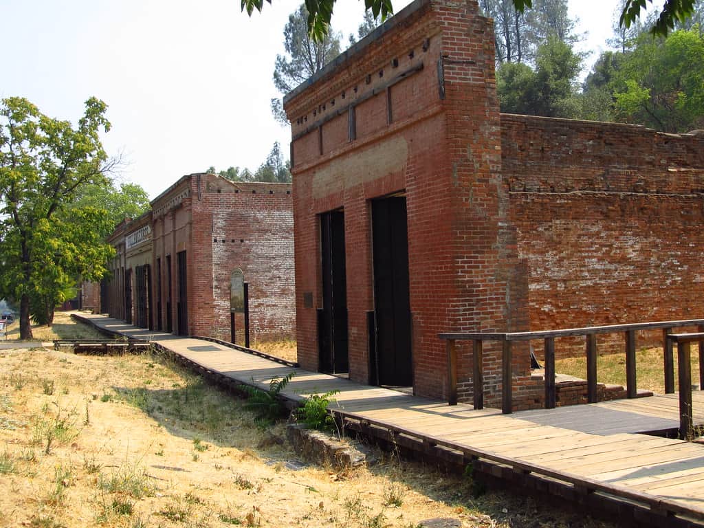
Shasta State Historic Park– The Gold Rush Town Along I-5
What makes it unique: This ghost town was formerly a busy river port.
Shasta State Historic Park protects and preserves the remains of old Shasta City, a ghost town north of Redding. Shasta was founded during the California Gold Rush in the early 1850s. Gold was discovered in the area, leading to a rapid influx of settlers and the establishment of a mining and commercial community.
Shasta quickly became an important commercial and transportation hub in the region. It was known as the “Queen City of the Northern Mines” and served as a supply center for miners and travelers heading to the goldfields.
The town boasted numerous businesses including hotels, saloons, general stores, and a theater. The construction of a courthouse and jail reflected Shasta’s aspirations to become the county seat. The town was plagued by fires, once in December of 1852 and again six months later, but the residents quickly rebuilt.
Gold claims in the area were largely depleted in the late 1860s and the town’s prominence further waned as other transportation routes, such as the railroad, bypassed the town. By 1888 the county seat was moved to Redding and many of the buildings were left abandoned.
Beginning in the 1920s, efforts were made to preserve the historic structures in Old Shasta. The California State Parks Commission began purchasing some of the old buildings, eventually forming Shasta State Historic Park, which covers over 300 acres.
The park preserves the historic district of Old Shasta, including the Litsch General Store, jail, blacksmith shop, and the Blumb Bakery. The ruins of the original brick courthouse, which burned down in 1861, has been rebuilt and is filled with historic exhibits. The park also offers interpretive programs, guided tours, and living history events.
Nearby Lodging:
Inn at Shasta Lake (about 25 min away)- A luxury B&B in nearby Lakehead that is surrounded by wooded nature. Breakfast is included, pets are welcome, and Shasta Caverns are nearby.
Mount Shasta KOA (about 30 miles north)- A full service KOA at the base of Mount Shasta with tent and RV sites as well as cabins to rent.
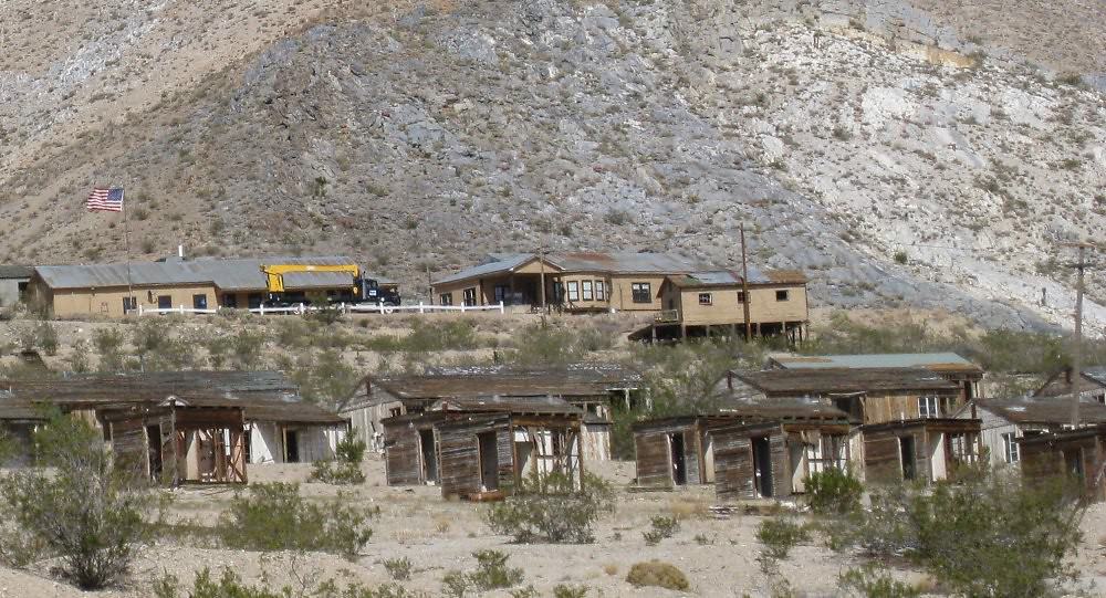
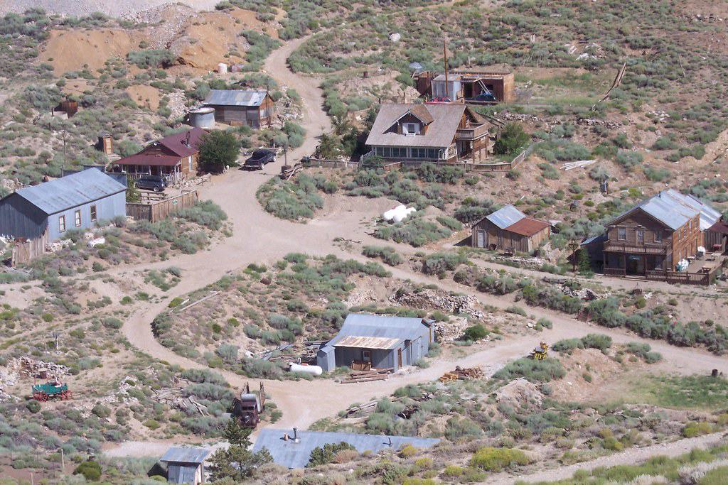
Cerro Gordo– A Boomtown Rising from the Dead
What makes it unique: You can watch a Youtube Channel and see the progress of one man’s goal of restoring Cerro Gordo.
Cerro Gordo is a historic mining town located in the Inyo Mountains of eastern California, near the town of Lone Pine. It gained prominence after the discovery of rich veins of silver was made by Pablo Flores in 1865. By 1867, word had gotten out and people began flocking to the area.
By the mid-1870s, Cerro Gordo experienced a mining boom and the town quickly grew into a bustling mining community, attracting fortune-seekers from different parts of the country.
The mines in Cerro Gordo were known for their high-grade silver ore, and the town became one of the most significant silver producers in California. At its peak, it was producing millions of dollars’ worth of ore annually.
The town boasted a range of structures, including mines, mills, a general store, saloons, a hotel, and housing for the miners and their families. The town’s growth reflected the prosperity brought by mining activities. It was also quite lawless and at one point there was a murder a week!
Cerro Gordo’s remote location in the Inyo Mountains posed significant challenges for transportation and logistics. Supplies and ore had to be transported over difficult mountain roads, adding to the town’s isolation. There was also a lack of water and timber which added to the town’s challenges.
As the easy-to-access silver ore was depleted, Cerro Gordo experienced a decline in the late 19th century. The town went through periods of boom and bust over the years, with mining operations intermittently resuming. During the early 20th century, zinc became the town’s main ore export.
These days, the town is privately owned. Cerro Gordo has gained notoriety in recent years since one of town’s owners, Brent Underwood, moved to the town in 2020 and began a very popular YouTube channel (over 1.6 million subscribers!) about life in the ghost town and his efforts to bring it back to life as a tourist destination.
The preservation efforts aimed at maintaining its historical integrity. Several of the town’s structures have been stabilized and restored, helping to preserve the town’s unique character. The American Hotel, which was built in 1871, burned down in 2020 and is currently being rebuilt for guests to enjoy.
Cerro Gordo is accessible by a rough mountain road, and visitors are advised to check conditions before attempting the journey. Most people who visit these days are volunteering to help restore the property. Hopefully in a few years it will be open for overnight stays. The best way to keep up with the town’s progress is to follow the YouTube channel.
Stay Nearby:
Lone Pine is the closest town to Cerro Gordo with lodging. It is a popular spot with backpackers looking to hike Mt. Whitney. The Mt. Whitney Motel is an afforable and highly rated option.
FAQ: Visiting Ghost Towns in California
What is the most famous ghost town in California?
Bodie State Historic Park is considered the most famous ghost town in California. It’s one of the best-preserved and most authentic examples of a Gold Rush-era town, with over 100 original buildings still standing.
Are California ghost towns safe to visit with kids?
Yes, many ghost towns like Calico and Laws are safe and family-friendly. These locations often offer interpretive displays, restrooms, and ranger-led programs, making them great for educational outings.
Do you have to hike to get to California ghost towns?
Not all ghost towns require a hike. Bodie, Calico, Randsburg, and Shasta are accessible by car. Others, like Panamint City, require moderate to strenuous hikes, so be sure to check access information before visiting.
Can you camp near California ghost towns?
Yes, many ghost towns are near established campgrounds or dispersed camping areas. For example, there’s camping near Cerro Gordo, Darwin, and Panamint City. Always follow Leave No Trace guidelines when camping near historic sites.
Are dogs allowed at California ghost towns?
In most state-run ghost towns like Bodie and Shasta, dogs are allowed on leash but may not be permitted inside buildings. Always check the specific ghost town’s pet policy before you go.
When is the best time of year to visit ghost towns in California?
Spring and fall are ideal times to visit, especially for towns in the desert like Amboy and Ballarat. Summer can be extremely hot, while winter access to some mountain towns like Doble or North Bloomfield may be limited due to snow.